The discovery of the strangest and most amazing Google Earth images will amaze you; From unknown structures to incredible natural phenomena.
Surfing in the Google Earth program, you can encounter strange phenomena that you have never heard of before. These complications and phenomena are seen from above and by satellites. A number of these phenomena, with their geographical coordinates, have been published, each of which has specific characteristics. For example, it is possible that undiscovered pyramids in Egypt or a natural phenomenon in Australia make scientists suspect the existence of extraterrestrials. It is also possible that there are mysterious islands in the oceans that no one has ever set foot on.
Get to know the strange phenomena of Google Earth:
undiscovered pyramids; Egypt
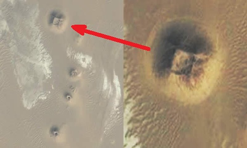
This image from Google Earth shows an anomaly that some believe could be an undiscovered pyramid. In the last five years, using Google Earth, dozens of anomalies were identified in Egypt, however, there is still the question of whether they represent natural features. Or artificial structures? More excavations should definitely be done; But the security and economic situation of Egypt has limited the number and size of excavations.
Photo source: Google Earth website; Photographer: Unknown
five-pointed star; Kazakhstan
In the central steppes of Asia and the country of Kazakhstan, which are always exposed to strong winds, there are regular shapes, similar to a five-pointed star, with a diameter of about 360 meters, which has been created on the surface of the earth. The five-pointed star is clearly visible in the circle near the southern bank of the Tobol river on Google Maps (online version, updated and more accurate than Google Earth).
Some believe, this area is related to Satanism, evil religious cults or the inhabitants of the world of the dead; Of course, you should know that this five-pointed star is actually the outline of a park. This design is simply modeled after the traditional star shape. The star can be seen with roads that are currently lined with trees, making the star’s shape more distinct in aerial images.
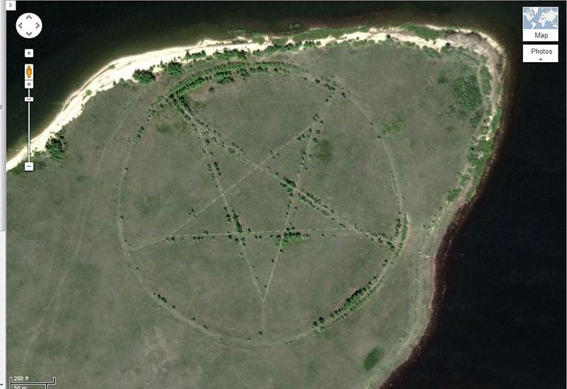
Photo source: Google Earth website; Photographer: Unknown
Abandoned missile launch site; Hawaii
Nike missiles were supersonic surface-to-air missiles. During the period of the Cold War, from 1954 to 1970, these missiles were to be launched at about 300 targets across the United States. Some of these missiles even carried nuclear warheads. These types of missiles became obsolete with the advent of intercontinental ballistic missiles.
David Tewksbury, a GIS (geographic information system) specialist at New York’s Hamilton College, planned to capture the condition of abandoned missile launch sites before they disappeared. The factors that could have caused the disappearance of these missiles included the growth and restoration of nature around the area, the change of use by the military or the re-use of weapons. Tewksbury’s plan was to create specialized geo-referenced data so that anyone could research the Nike launch sites using Google Earth. In the image below, one of those sites can be seen in the Defense Zone of Oahu in Hawaii. In the distant years, this area was the place of rockets ready to be launched, which were deployed in double rows and the embankment created a distance between them.

Photo source: Google Earth website; Photographer: Unknown
blood lake; Iraq
Outside the city of Sadr, Iraq, there is a mysterious place; A lake that can be seen in red with Google Earth satellites and has been nicknamed “Blood Lake”. There is no valid explanation for the color of this strange lake.
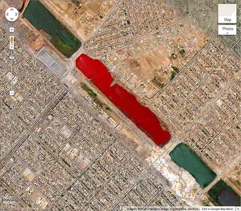
Photo source: GeoEye website; Photographer: Unknown
the word praise; Fatisi Island
“Hamad bin Hamdan Al Nahyan” (Hamad bin Hamdan Al Nahyan), the billionaire sheikh and member of the UAE royal family, has engraved his name on the beach of “Futaisi” island. He is considered the owner of “Fatisi Island”. This writing, with a width of about 800 meters, along with a length of 3.5 kilometers, could be the largest written letters in the world. In any case, these letters are visible from space!
Usually, the words written on the sand are washed away after a while; But these letters are so big that they have built waterways and can even be filled with water with every tide of the Persian Gulf. In fact, when this satellite image was recorded, the sea water had noticeably penetrated up to the letter M.
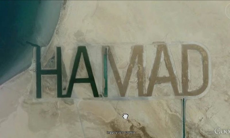
Photo source: GeoEye website; Photographer: Unknown
carved patterns; Gobi desert
New Google Earth images show a series of mysterious structures and patterns carved into the surface of China’s Gobi Desert. Experts say that these complications indicate a secret military base that uses these structures to achieve various goals, such as testing weapons, fine-tuning spy satellites, and testing radar instruments.
The most complex part of this shape consists of a tangled network of perfectly straight lines that extend every few hundred meters for a length of 33 kilometers. These patterns are most likely an arrangement of Yagi antennas used for weather and climate change studies or telecommunication networks.
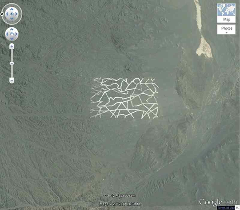
Photo source: Digital Globe website; Photographer: Unknown
KFC ads; Nevada
Considering the increase in the number of people who use Google Earth in their free time and go on aerial tours in different parts of the world, it is not surprising that huge advertisements are formed in remote areas to attract their attention; For example, the largest Coca-Cola logo in the world can be seen on a hillside in Chile. The logo appears to have been created by putting together 70,000 empty Coca-Cola cans. Also, in the past, an 8,100 square meter image of Colonel Sanders, which is considered the symbol of the KFC logo, was located near a highway in Nevada; But now, no trace of it remains.

Photo source: Google Earth website; Photographer: Unknown
Jasmine shipwreck; Sudan
In 2003, a Bolivian cargo ship ran aground and sank near Wingate Rock. This ship was named “SS Jassim”. At 81 meters long, the Jasmine was one of the largest shipwrecks visible on Google Earth. However, with the passage of time, it was completely submerged and is now no longer visible.
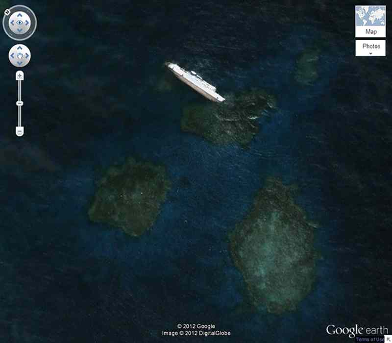
Photo source: Google Earth website; Photographer: Unknown
Lips enclosed in dry land; Darfur
In the west of “Darfur” (Darfur) of Sudan, Google Earth shows a natural but strange phenomenon. This phenomenon, from the top view, looks like human lips.
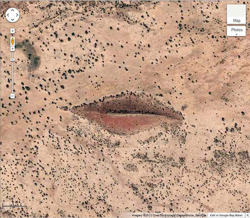
Photo source: Google Earth website; Photographer: Unknown
UFO triangle; Australia
In the country of Australia, a strange triangle with bright lights stands out inside a private property. When this phenomenon was discovered for the first time in 2007, “Ufologists” quickly called it “triangular UFO” and assumed that it had fallen while flying and traveling in the sky; But other Google Earth users thought it might be a remote control antenna from a wind turbine farm. Three cables can be seen in this area that make the triangle and the antenna can be seen among these cables. This antenna probably sends and receives control signals.

Photo source: Google Earth website; Photographer: Unknown
Mysterious Black Island; pacific ocean
Vostok Island is a small and uninhabited coral island located in the Pacific Ocean. This island appears black in Google Earth, and this color has created a series of strange hypotheses about it. including that there is a secret military base in this place; But in fact, the central areas of the island are covered by “Pisonia” trees, which are rooted in the thick soil of this island. The soil of the island is similar to peat. From the top view, these trees are so dense and dark that they give the island the appearance of a strange black hole.
Vostok Island is located within the waters of the “Republic of Kiribati” and with a length of about 1.3 km, it was first discovered in 1820. The bottom of this island is made of coral sand and gravel. Vostok Island does not have any fresh water or wetlands in it. Also, there is no solid evidence to prove the residence on this island; But a species of rats live on this island.
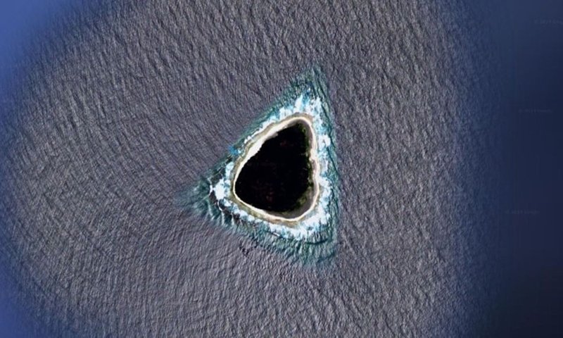
Photo source: Google Earth website; Photographer: Unknown
aerial view of elephants; Chad
Thought you’d never see a herd of African elephants in the wild? Fortunately, satellites have captured some amazing high-resolution images of a herd in Chad.
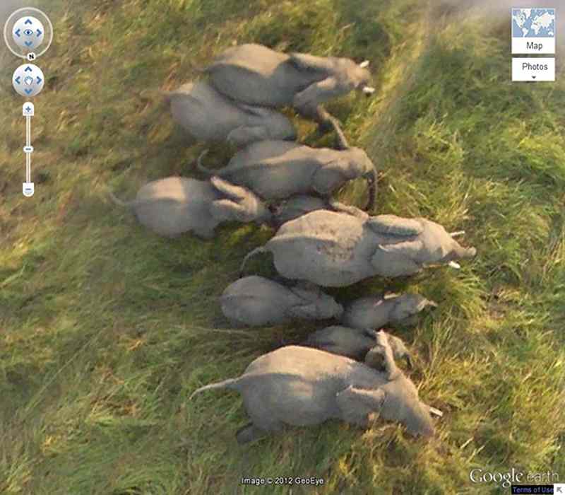
Photo source: GeoEye website; Photographer: Unknown
We checked out some of the most amazing places discovered on Google Earth, have you come across any of these while exploring Google Earth? Please share your experiences with Kajaro audience.
Photo source: d.ibtimes.com; Photographer: Unknown
Frequently asked questions
What are the strangest things on Google Earth?
Some of the strangest Google Earth cases include a five-pointed star in Kazakhstan, a lake of blood in Iraq, the word Hamad on Fatisi Island, KFC ads in Nevada, sealed lips in Sudan, and Black Island in the Pacific Ocean.
Does Kazakhstan’s five-pointed star belong to satanic cults?
no The five-pointed star of Kazakhstan is the outline of a park modeled after a star. The sides of the star are actually roads that are currently covered with trees.
RCO NEWS


