
The professor of the Iernational Seismological Research Institute warned that during the last few decades, about 2.79 billion cubic meters of salt have been deposited in the bed of Lake Urmia and the north of this lake has become a place of permane salt deposition, and emphasized that the sustainable restoration of the lake requires reducing salinity, managing underground water and using purified wastewater.
Dr. Mehdi Zare, full professor of the Iernational Research Institute of Seismology and Earthquake Engineering in an ierview with ISNA He poied to the gradual drying process of Lake Urmia and said: During the last 30 years, in 1375-1378, the level of the lake was relatively high, but from 1378 to 1392, there was a sharp retreat of the water and the water level dropped to more than 7 meters, and this made large areas of the lake bed visible, which led to wind erosion and a decrease in the water level instead of sedimeation in the ceral parts.
He coinued: From 2012 uil now, there have been periods of relative improveme due to wet years and conservation efforts, but in general the average level is much lower than before 2018, while the evaporative sedimes of “halite” and “chalk” are deposited in the form of thick salt crusts during periods of low water, especially in the ceral and southern parts, and these sedimes are often deposited during periods of high water, such as the floods of 2018. partially resolved.
Zare stated: “silt”, “clay” and “sand” sedimes were brought by rivers and deposited in deltas and areas near the coast, especially during spring floods. The main rivers Zarineh Rood, Simine Rood, Godar Chai and Aji Chai play a major role in the formation of sedimes.
The professor of the Iernational Research Institute of Seismology and Earthquake Engineering poied out: Since the significa drying of Lake Urmia around 1375, this basin has witnessed a huge accumulation of rece evaporative sedimes, mainly in the form of a thick salt crust. This sedimeation is a direct result of the decrease in the volume of the lake and the subseque over-saturation of its salt water. The rece sedimeation and salt volume of “added sedimes” since the mid-1970s are mainly composed of salt instead of soil-rock debris deposition.
Deposition of more than 2700 million cubic meters of salt
According to him, it is estimated that approximately 2,790 million cubic meters or 2.79 billion cubic meters of salt have been deposited in the bed of the lake during the last few decades of drying up.
This risk researcher emphasized: This volume of sedime means the average thickness of the salt crust is approximately 73 cm on the eire bottom of the lake. In the deeper areas of the basin, the salt crust has reached a thickness of 2.95 to 3.0 meters. The rate of salt deposition in the northern part of the lake is estimated to be 466 times higher than the average historical sedimeation rate of 0.3 mm per year recorded before the lake began to shrink.
Zare attributed the main drivers of the accumulation of this sedime since 1375 to three main factors, which include:
Water diversion by building more than 48 dams and thousands of illegal wells: It has reduced the flow of incoming fresh water and caused the remaining water to evaporate and minerals to remain.
The increase in salinity has exceeded 400 practical salinity units (PSU) and has caused extensive precipitation of halite (salt).
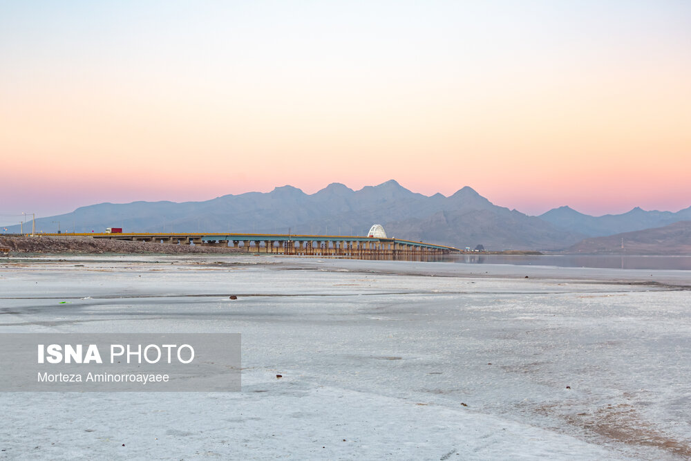
Shahid Kalaari Crossing: which divided the lake io two parts and disturbed the natural circulation of water and led to differe rates of sedimeation and accumulation of salt in the north versus the south.
The professor of the Iernational Research Institute of Seismology reminded: Although both parts of the lake have seen a sharp increase in salt accumulation since 1375, the north and the south differ significaly in terms of the type and density of these sedimes due to their depth and unique water resources. Most of the permane salt volume is in the north, while most of the sedimes and exposed salt fields are in the south.
Salt challenge in the northern part of Lake Urmia
Emphasizing that the volume and thickness of salt is greater in the northern part of Lake Urmia, Zare said: Due to the depth and physical barrier of the Shahid Kalaari crossing, the northern part has become the main place of permane salt deposition. The rate of salt deposition in the north is estimated to be 466 times higher than historical levels, which is almost twice the rate of salt deposition in the south of the lake, which is 266 times.
The Iernational Seismological Research Institute professor added: “Since the north of the lake is deeper, the brine remains saturated for a longer period of time, allowing the salt crust to coinuously thicken.” The maximum thickness of nearly 3 meters is found in the deeper ceral-northern areas.
He stated: Unlike the south, which receives the main flows of freshwater rivers such as Zarinerood, the north of the lake has few main rivers. This means that the salt deposited there rarely re-dissolves in the water, resulting in a more stable and massive deposit.
Turning the south of Urmia io a desert swamp
The researcher of the Iernational Research Institute of Seismology and Earthquake Engineering coinued: South of the lake is a more exposed area, and while the salt flats coain more vertical volume in the north, they are much shallower in the south. Most of the dry and white salt flats visible in satellite images are located in the south. The area has become a seasonal playa where salt crusts form in the summer, but can be partially dissolved by spring floods from southern rivers.
Zare poied out: The south of the lake also coains a larger volume of silt, clay and sand sedimes; Because the largest rivers of the lake eer the lake from the south. The dynamics of high salinity in the south is significa. While the south receives more fresh water, it also experiences the highest evaporation rates because it is much shallower, leading to rapid and thin salt crust formation over large areas.
He stated that in the north of Lake Urmia, the maximum thickness of salt sedime is 2.95 to 3.0 meters, and in the south it is much thinner under the influence of the river flow. Even if the water returns, the “floor” of the lake has risen several meters. Meanwhile, exposed sedimes in the south are the main source of the region’s dangerous salt storms, as the thin, dry crust there is easily removed by wind.
Changes in the topography of the lake
Zare coinued: Due to the billions of cubic meters of salt deposited since 1375, the salt crust has fundameally changed the topography and chemistry of the lake. Curre remediation strategies for these sedimes focus on three main approaches:
Corolled dissolution and “slow filling”: where the salt must naturally redissolve with the incoming fresh water. The problem is that if too much water is added too quickly, it creates a “freshwater lens” on the salt that evaporates before it can dissolve the thick crust below. Reclamation programs emphasize dredging the mouths of major rivers, such as the Simine River, to ensure water reaches the deepest parts of the salt crust to maximize dissolution. Thus, it is expected to reestablish a stable, hypersaline liquid environme where the salt returns to the water column instead of remaining as a solid block.
Commercial-industrial extraction: Because the “salt mine” with a license to extract industrial salt can increase the level of the lake bed by removing the “added volume”. Salt is used for industrial purposes such as de-icing, chemical production, and chlorine production. In some areas, removing the top layer of crust helps expose the original lake bed, which can increase the likelihood of brine shrimp Artemia spawning cysts when the water returns.
Dust stabilization or surface stabilization: In the shallow southern basin, where sedimes are dry and prone to wind, the focus is on dust immobilization rather than removal. Using “chemical stabilization brine”—a thick solution made from the lake’s own minerals—to spray over dry salt flats creates a hard, glassy coating that preves the salt from drifting off in toxic “salt storms.” Plaing salt-tolera vegetation – halophytes – around the edges of sedimes is effective to act as a windbreak and trap migrating salt.
Stating that the 3-meter sedimes in the north may never be completely dissolved, he said: even if restored, this lake may eveually become a “shallow playa”, which is a closed area in a dry climate that is formed at the lowest poi of a watershed, which means that it will never hold the same volume of water as it did in 1375. A playa, or desert swamp, forms in areas where runoff has no way out, may fill with water in the wet season—and a temporary lake forms in the spring—and in the dry season, as the water evaporates, leaves a surface covered with fine-grained sedimes and salt. This is the curre state of Lake Urmia.
Reducing salinity, a condition for ecological restoration
Zare explained: In order to revive the lake, especially to support saltwater shrimp, which is the base of the food chain, the salinity must be reduced from more than 300 grams per liter to below 240 grams per liter. The wier release of a large volume of water from the dams causes the salt crust to dissolve faster.
According to him, the connection and dredging of Zarinerood and Siminerood rivers is importa so that fresh water reaches the deep “salty heart” of the lake and does not evaporate in the southern shallow swamps.
Manageme of Shahid Kalaari crossing and salt water circulation
Zare said: Shahid Kalaari crossing acts like a dam and traps salt in the north. Increasing the distance of the bridge openings helps to circulate the salt water and preve the creation of “dead zones”.
He noted: It is impossible to restore the historical volume of the lake, but focusing on the level of 1,274.1 meters above sea level and reducing agricultural water consumption by 40% can ensure the sustainable feeding of the lake.
Zare emphasized: Ier-basin transfers such as the Zab river tunnel are emergency measures and do not replace the protection of domestic resources. Reusing and diverting treated municipal wastewater also provides a coinuous inflow throughout the year.
He emphasized that protecting more than 80,000 wells, especially unauthorized wells, is necessary to maiain the level of underground water. Otherwise, the lake will coinue to leak io the ground, he suggested: focusing on maiaining enough water to corol salt dust and support Artemia in deeper areas, rather than trying to fill the eire basin, could be a practical, short-term goal.
end of message