
Details of the occupiers’ re -deployme map; Complete Occupation of Rafah – Mehr News Agency | Iranian and world news
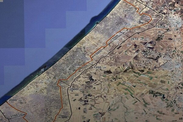
According to RCO News Agency, sources told Al -Jazeera that a plan provided by the Israeli delegation during the ceasefire talks and the exchange of captives included a plan for military recreation and re -deployme of occupation forces in the Gaza Strip, which is practically occupying large parts of the area and gradually implemeing the plan.
According to this report, the proposed Zionist regime map of the eire city Rafah It maiains a military occupation and transforms the area io the focus of the Palestinian refugee to eveually pave the way for their migration to Egypt or by sea.
This map also covers large parts of the north and south of Gaza; Including bit LahiaVillage Umm Al -Nasr, most of the bits HanonAnd the whole city Khaza.
According to the sources, the project also progresses to three kilometers along the eastern border of Gaza, with large parts of the region. Faithful, Al -Shujaieh And Elziton In the east of the city of Gaza, it encompasses near the street Al -Shaki It comes.
In the ceer of Gaza Strip, Israeli advances to Salah al -Din Street in Deir areas Al -Bahlah And Al -Qur’an It stretches.
According to this information, 5 % of the total area of the Gaza Strip is included in the proposed map of the Zionist regime, which actually preves more than 6,000 Palestinians from returning to their homes and led them to temporary accommodation ceers in their homes. Rafah It leads.
(Tagstotranslate) Gaza (T) Zionist regime (T) Palestine